Pages

Showing posts with label earth. Show all posts

Nov 1, 2012

Google Earth for desktop gets tour guide feature and additional 3D imagery

Google Earth 7 is now available for download, with the Mountain View company adding the tour guide feature from the Android and iOS versions together with a load of new 3D imagery.

The latest version of Google Earth for desktop computers was rolled out on Wednesday, bringing many of the features that Android and iOS users of the virtual-globe software have been enjoying for a few months now.

Version 7 brings with it the tour guide feature, which Google describes as “a local expert”. To try it out, look for thumbnails appearing at the bottom of the screen as you’re viewing various locations around the world. These thumbnails indicate that a tour has been created. Click on one that looks appealing and you’ll be taken on a virtual flyover of the landmark or location, with various relevant facts and figures pulled from Wikipedia showing up on screen.

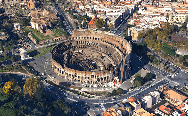
As you might expect, the feature works best with cities where buildings have been rendered in 3D by Google, rather than in locations like Paris which are still waiting for a makeover. Flying around an Eiffel Tower showing up as flat as a pancake is, of course, no fun at all. The Golden Gate Bridge in San Francisco and Rome’s Colosseum, on the other hand, both offer a superb demonstration of the feature. To view the buildings in 3D, you need to first check the 3D Buildings box in the layers column on the left side of the screen. To find out more about which landmarks are currently viewable in 3D, check out Google’s dedicated webpage here.

Locations updated with 3D imagery on Google Earth 7 include those that have been available on Android and iOS devices for several months such as Boulder, Boston, Charlotte, Denver, Lawrence, Long Beach, Los Angeles, Portland, San Antonio, San Diego, Santa Cruz, Seattle, Tampa, Tucson, Rome and the San Francisco Bay Area (including the Peninsula and East Bay).

And there’s more – from Wednesday additional 3D imagery is showing up for a number of other places including Avignon, France; Austin, Texas; Munich, Germany; Phoenix, Arizona; and Mannheim, Germany.

“The experience of flying through these areas and seeing the buildings, terrain and even the trees rendered in 3D is now consistent across both mobile and desktop devices, making all of your virtual travels more realistic than ever,” Google Earth product manager Peter Birch said in a blog post announcing the update.

Uou can download Google Earth 7 here.


Source : digitaltrends[dot]com

Sep 29, 2012

Google rolls out more improvements to its mapping tools following Apple’s Maps apology

Google rolled out more new and refreshed imagery for its Maps and Earth tools on Friday, the same day that Apple CEO Tim Cook issued a letter of apology for the "frustration" caused by the Cupertino company's new Maps app.

Google employees charged with keeping the company’s mapping tools in tip-top shape must currently be walking around the Mountain View offices with a spring in their step so bouncy they run the risk of banging their heads on the ceiling with every stride.

The Web giant always knew it had some good stuff going on with Maps and Google Earth, but after the disastrous launch of Apple’s Maps app recently, its offerings suddenly look even better.

And as Apple boss Tim Cook issued a letter of apology to iOS users on Friday regarding the Maps mess, Google was busy rubbing salt into the wound by uploading improved imagery to its own mapping tools. In the apology letter, Cook even went as far as to recommend people use Google Maps, among other similar services, until Apple improves its own offering.

In a post on its Lat-Long blog Friday, Google’s Bern Steinert announced refreshed high-resolution aerial and satellite imagery for a slew of locations around the world, as well as some brand new 45-degree imagery.

Google’s 45-degree imagery goes up against the Flyover feature on Apple’s Maps app, which offers photo-realistic, interactive 3D views of major cities around the world. In Google Maps, you’ll find new 45-degree views for 37 US and 14 international locations. Steinert offered up a picture of Italy’s Leaning Tower of Pisa by way of example.

More than 100 countries and 17 cities have been updated with new high-resolution aerial and satellite imagery in both Maps and Earth. Check out the blog post for detailed information regarding locations.

Google is constantly adding new features to Maps and Earth in a bid to hold its position as the leading provider of online mapping tools. Its Street View service recently threw on a pair of flippers to explore some spectacular ocean scenery off the coast of Australia, the Philippines and Hawaii.

“Our quest to create the most comprehensive and accurate map of the world is ongoing, but we’re happy to take a pause and share some impressive progress that our Google Maps and Earth imagery teams have recently made,” Steinert said in the blog post introducing the new imagery, no doubt with a massive smile on his face when he wrote it.


Source : digitaltrends[dot]com

Sep 26, 2012

Google Maps + Google Earth = Google iOS 6 app

Google Maps Google Earth coming to iOS 6

Google will reportedly combine Google Maps and Google Earth in its forthcoming app for Apple iPhones and iPads -- but you may have to wait a while to get it.

Apple iPhone users, rejoice! Google is building a new Google Maps app for iOS 6 that will reportedly combine the features of the old app with the whiz-bangery of Google Earth, according to a report from The New York Times. The only downside: It’s still a long way off.

Apparently, Apple blind-sided Google when it decided to drop Google Maps from iOS 6. The Verge and The New York Times report that, according to anonymous sources, Apple’s contract to use Google’s navigation app still had a year of life left when Cupertino told Mountain View that it would no longer need its mapping services. Because of this, Google had not yet begun to build out a new version of Google Maps — which is the reason the company does not have a new Google Maps pending with Apple now.

Apple’s reported decision to drop Google Maps is said to have come before Apple’s 2012 Worldwide Developers Conference (WWDC) on June 11, when the company unveiled iOS 6 and its new Maps App. Google responded by holding its own Google Maps event ahead of WWDC, on June 6, which showcased some of its new 3D mapping technology — a feature that is expected to make its way into the new Google Maps.

The reason everyone cares so much about a new Google Maps is, of course, because Apple’s new Maps app is packed full of inaccuracies, strangely distorted landscapes, and lacks public transit information. Apple has already corrected some of these failings, and promises that it will get better over time.

In the end, this will all work itself out. And even now, it’s not that bad. Apple Maps, sub-par in some respects though it may be, works perfectly well for many users. In China, at least, it’s apparently far better than Google Maps ever was. The turn-by-turn navigation is quite useful. And 3D view — while entirely impractical for finding where you need to go — is at least fun to look at while bored. That’s something, right?


Source : digitaltrends[dot]com

Sep 10, 2012

Pope Benedict XVI goes green with electric Popemobile

Renault Kangoo Maxi ZE electric Popemobile

An electric Renault Kangoo Maxi ZE will transport Pope Benedict XVI around his summer residence.

The Vatican is one of the smallest sovereign states on Earth, but it’s still concerned about carbon emissions. Pope Benedict XVI recently added a new vehicle (Popemobile to us heathens) to his official fleet, and it is powered by electricity.

The new Popemobile is based on the Renault Kangoo Maxi ZE, an electric version of the compact van Renault sells in Europe. In place of an internal combustion engine, the Kangoo has a 60 hp electric motor and a lithium ion battery pack.

This Popemobile clearly isn’t built for speed, but at least people will have plenty of time to see the Pope as he passes by. The battery pack yields a 105-mile range, which should be more than adequate for this application. Renault says Benedict XVI will use the Kangoo for transportation at his summer residence in Castel Gandolfo, Italy, which is only five square miles.

Modifications for Papal service include a redesigned interior from French coachbuilder Gruau, with two bucket seats replacing the stock taxi-like bench. A traditional all-white paint scheme with the Papal coat of arms lets everyone know who is riding in this Renault.

However, unlike other Popemobiles, the Kangoo does not have an elevated glass box for putting the leader of the Catholic faith on display. Since it will be transporting the Pope in private, there really is no need. Still, the Kangoo’s big windows and sunroof should allow it to pinch-hit as parade transportation if necessary.

The Pope’s usual transportation consists of a fleet of modified Mercedes-Benz M-Class SUVs; the Vatican has also used the Mercedes G-Class for past Popemobiles.

The Kangoo Maxi ZE Popemobile was presented to the Pope by Renault Nissan CEO Carlos Ghosn. Through an ever-expanding line of Nissan (Leaf, eNV200, Infiniti LE) and Renault (ZE models) EVs, Ghosn has made electric propulsion a priority at the French and Japanese juggernauts. Building an EV for the Pope shows that there is always a new niche, even at the Vatican.


Source : digitaltrends[dot]com

Sep 8, 2012

Google Earth/Maps adds new satellite, aerial and 45-degree imagery for locations worldwide

Google has updated its Earth and Maps products with a stack of new and refreshed satellite, aerial and 45-degree imagery.

As competition intensifies in the world of online mapping, Google continues to refresh and add to its existing data, on Friday rolling out ever more detailed satellite and aerial imagery for a plethora of locations around the world.

Detailed in a post on the Web giant’s Lat-Long blog, Google geo data strategist Eric Kolb said users would be able to enjoy “another extensive refresh to our high resolution aerial and satellite imagery, as well as new 45-degree imagery in Google Maps spanning 30 new cities.”

Google Earth is already showing new aerial shots for over 20 locations, together with refreshed satellite imagery for over 60 different regions around the world. In his post, Kolb said the new aerial and satellite data isn’t yet showing on Maps but will be soon. However, Maps is already showing the 45-degree imagery.

Countries with refreshed high-res satellite data include the US, Brazil, Morocco, Japan, Australia and New Zealand.

Bordeaux in France, San Sebastian in Spain, Rome in Italy, Salzburg in Austria and the UK’s Olympic Park are just a few of the locations featuring new high-res aerial imagery, together with a bunch of places across the US.

New 45-degree imagery has been introduced for 23 US cities – among them Bend OR, Buffalo NY, Cincinnati OH and Wilmington NC – as well as seven international locations, including Bordeaux and Marseille in France, and Blanes in Spain.

The entire list of places displaying new or updated imagery can be found in Kolb’s blog post here.

Google is continuing to work hard on improving its map-based offerings, with new features and updates being introduced all the time. Other companies are beginning to move into the space, encouraged by businesses and app developers looking elsewhere for Web-based mapping data following Google’s decision to start charging for it.

OpenStreetMap has been gaining a lot of fans recently, and at next week’s Apple event we should be getting a launch date for iOS 6, which will bring the Cupertino’s own Maps app to the home screen of millions of iPhones and iPads around the world, replacing Google Maps as the default map provider.


Source : digitaltrends[dot]com

Aug 15, 2012

DT Daily: Pinterest for Android, lost pyramids, driverless cars attacked

Pinterest finally gets an Android app, Microsoft's tablet could sell for cheap, Google Earth may have uncovered lost pyramids in Egypt, Bill Gates seeks to reinvent the toilet, and driverless cars come under attack.

Related Links:


Source : digitaltrends[dot]com